
Incheon’s Yeongjong-gu District (Governor Son Hwa-jung) has built, using its own technology, a “Smart Field Map for Flood-Response Storm Drains” that allows real-time tracking of the locations and conditions of 13,201 storm drains across the district in preparation for summer torrential rains, and began full-scale operation of the system on the 14th.
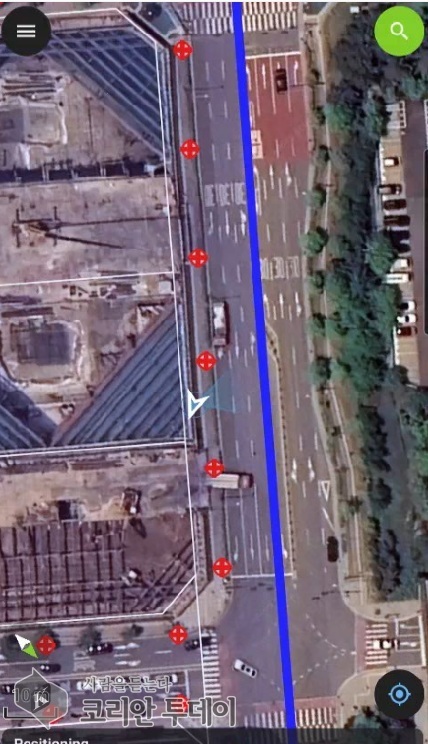 [The Korean Today] Demonstration of the smart field map for storm drains © Reporter Kim Mi-hee |
Storm drains are the frontline flood-control facilities that channel rainwater pooled on roads into sewer pipes to prevent flooding. When clogged with foreign matter such as fallen leaves or trash, the speed of flooding is known to increase more than threefold, making it critical during summer disaster response to accurately identify their locations and conditions and repair them promptly. The district said it introduced the map to strengthen on-site initial response capabilities and protect residents’ lives and property amid climate conditions in which localized torrential rains are becoming more frequent.
The newly introduced map runs on Qfield, a mobile application based on the open-source geospatial program QGIS. Its distinguishing feature is that it applies field-oriented mobile geospatial technology tailored to local conditions, designed to manage the 13,201 storm drains in the Yeongjong area scientifically and systematically.
In particular, even in poor communication environments—such as when Wi-Fi is disconnected or in data dead zones—the system can link with GPS to display in real time on the map the locations of field workers and nearby storm drains. The district expects this to help protect the safety of workers even at night, when visibility is limited, while also enabling them to accurately locate storm drains in unfamiliar terrain and quickly clear any blockages.
The map goes beyond simply marking locations: it allows users to look up a unique management number for each storm drain, and when an abnormality is found on site, workers can mark and record it with a pin in the application—an advancement said to have significantly improved the precision of management.
The project also carries significance in that the district built the system entirely with its own GIS technological capabilities through inter-departmental administrative collaboration, without relying on outside contractors. It is cited as a case in which a practical disaster-response tool was created using in-house capacity without incurring separate budget expenses.
After confirming the system’s stability through a pilot run, the district distributed the map data and a usage manual to the disaster response department and six dong offices—Yeongjong-dong, Yeongjong 1-dong, Yeongjong 2-dong, Unseo 1-dong, Unseo 2-dong and Yongyu-dong—so that officials could immediately put it to use. In line with the summer natural disaster countermeasure period running from May 15 to October 15, the district plans to continuously gather feedback through September from officials using the map in the field to refine the map data. It will also review, in consultation with relevant departments, ways for the map to be used by the private sector in the future.
Yeongjong-gu District Governor Son Hwa-jung said, “The cornerstone of preventing urban flooding is the scientific management of storm drains, the frontline flood-control facilities,” adding, “We will make every effort to thoroughly protect the lives and property of our residents from sudden downpours by using the smart field map.”
[ Reporter Kim Mi-hee: incheonsouth@thekoreantoday.com ]
Become a Local Ambassador Apply as Branch Director The Korean Today — Nam-Incheon
 |
THE KOREAN TODAY × WIA CODE
이 기사의 WIA Code

WIA Code 스캐너로 비추면 인터넷 없이 발행 사실과 위·변조 여부를 확인할 수 있습니다.
휴대폰 기본 카메라로 찍으면 스캐너 안내 페이지가 열립니다 — 기사 바로 열기

움직이는 코드는 스트림입니다 — WIA Code 스캐너로 약 40초 비추면 기사 전문(사진 포함)이 폰에 저장되어 인터넷 없이도 읽을 수 있습니다.
WIA Code · 코리안투데이






Leave a Reply